Survey data on PDFs is referenced to Louisiana South State Plane Coordinates North American Datum 1983 with soundings referenced below Low Water Reference Plane 2007 via N.A.V.D. gage in U.S. Survey Feet. XYZ files are in U.S. Survey feet referenced to N.A.V.D unless otherwise noted.
| Mississippi River Shallow Draft | ||||||
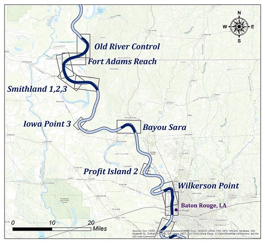
| Survey title | Survey date | Survey date | ||||
| Sheet Name River Mile | Recon - Profile Only | Full Survey | ||||
| Mississippi River Shallow Draft Crossings | ||||||
| Old River Control | 07/25/2019 | 10/23/2025 | ||||
| MS_07_OLD MM 315 to 309.5 | XYZ | Shape | XYZ | Shape | ||
| Fort Adams Reach | 07/25/2019 | 11/04/2024 | ||||
| MS_08_FAR MM 309.5 to 305 | XYZ | Shape | XYZ | Shape | ||
| Smithland - Sh. 1 | 07/23/2019 | 09/23/2025 | ||||
| MS_09_SM1 MM 305 to 300 | XYZ | Shape | XYZ | Shape | ||
| Smithland - Sh. 2 | 07/24/2019 | 09/24/2025 | ||||
| MS_10_SM2 MM 300 to 296 | XYZ | Shape | XYZ | Shape | ||
| Smithland - Sh. 3 | 10/26/2022 | 09/24/2025 | ||||
| MS_11_SM3 MM 296 to 291 | XYZ | Shape | XYZ | Shape | ||
| Iowa Point - Sh. 3 | mm/dd/yyyy | 10/23/2025 | ||||
| MS_17_IP3 MM 281 to 279 | XYZ | Shape | XYZ | Shape | ||
| Bayou Sara | 02/18/2025 | 10/02/2025 | ||||
| MS_24_BYS MM 267 to 264 | XYZ | Shape | XYZ | Shape | ||
| Profit Island - Sh. 2 | mm/dd/yyyy | 09/21/2019 | ||||
| MS_31_PI2 MM 252 to 250 | XYZ | Shape | XYZ | Shape | ||
| Wilkerson Point | 09/22/2020 | 11/14/2025 | ||||
| MS_39_WIL MM 236 to 233 | XYZ | Shape | XYZ | Shape | ||