Survey data is referenced to Louisiana South State Plane Coordinates North American Datum 1983 with soundings referenced below Mean Low Gulf in U.S. Survey Feet.
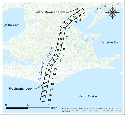
| Freshwater Bayou | |||
| Survey title | Survey date | ||
| Sheet Name River Mile | XYZ | SHP | |
| Upper - Sh. 1 | 06/03/2025 | ||
| FB_01_UPR MM 19 | XYZ | Shape | |
| Upper - Sh. 2 | 06/03/2025 | ||
| FB_02_UPR MM 18 | XYZ | Shape | |
| Upper - Sh. 3 | 06/03/2025 | ||
| FB_03_UPR MM 17 | XYZ | Shape | |
| Upper - Sh. 4 | 06/03/2025 | ||
| FB_04_UPR MM 16 to 15 | XYZ | Shape | |
| Upper - Sh. 5 | 06/03/2025 | ||
| FB_05_UPR MM 14 | XYZ | Shape | |
| Upper - Sh. 6 | 06/03/2025 | ||
| FB_06_UPR MM 13 | XYZ | Shape | |
| Upper - Sh. 7 | 06/03/2025 | ||
| FB_07_UPR MM 12 to 11 | XYZ | Shape | |
| Lower - Sh. 8 | 06/03/2025 | ||
| FB_08_LWR MM 10 | XYZ | Shape | |
| Lower - Sh. 9 | 06/03/2025 | ||
| FB_09_LWR MM 9 | XYZ | Shape | |
| Lower - Sh. 10 | 06/03/2025 | ||
| FB_10_LWR MM 8 to 7 | XYZ | Shape | |
| Lower - Sh. 11 | 06/03/2025 | ||
| FB_11_LWR MM 7 to 6 | XYZ | Shape | |
| Lower - Sh. 12 | 06/04/2025 | ||
| FB_12_LWR MM 5 | XYZ | Shape | |
| Lower - Sh. 13 | 06/04/2025 | ||
| FB_13_LWR MM 4 | XYZ | Shape | |
| Lower - Sh. 14 | 06/04/2025 | ||
| FB_14_LWR MM 3 to 2 | XYZ | Shape | |
| Lower - Sh. 15 | 06/04/2025 | ||
| FB_15_LWR MM 2 to 1 | XYZ | Shape | |
| Bar - Sh. 16 | 06/04/2025 | ||
| FB_16_BAR MM 0 | XYZ | Shape | |
| Bar - Sh. 17 | 06/04/2025 | ||
| FB_17_BAR MM (-1) | XYZ | Shape | |
| Bar - Sh. 18 | 06/04/2025 | ||
| FB_18_BAR MM (-2) | XYZ | Shape | |
| Bar - Sh. 19 | 06/04/2025 | ||
| FB_19_BAR MM (-3) to (-4) | XYZ | Shape | |