Survey data is referenced to Louisiana South State Plane Coordinates North American Datum 1983 with soundings referenced below Mean Low Gulf in U.S. Survey Feet.
| Morgan City Area | |||
| Survey title | Survey date | ||
| Sheet Name River Mile | XYZ | SHP | |
| Atchafalaya River | |||
| Above Stout's Pass - Sh. 13 | 04/30/2021 | ||
| AS_13_S2M MM 106.0 to 108.0 | XYZ | Shape | |
| Above Stout's Pass - Sh. 12 | 10/15/2025 | ||
| AS_12_S2M MM 108.0 to 110.0 | XYZ | Shape | |
| Above Stout's Pass - Sh. 11 | 10/15/2025 | ||
| AS_11_S2M MM 110.0 to 112.0 | XYZ | Shape | |
| Stout's Pass - Sh. 10 | 06/03/2026 | ||
| AS_10_S2M MM 112.0 to 114.0 | XYZ | Shape | |
| Stout's Pass - Sh. 9 | 06/03/2026 | ||
| AS_09_STP MM 114.0 to 116.0 | XYZ | Shape | |
| Stout's Pass - Sh. 8 | 06/03/2026 | ||
| AS_08_STP MM 116.0 to 118.0 | XYZ | Shape | |
| American Pass | 06/17/2026 | ||
| AS_00_AMP | XYZ | Shape | |
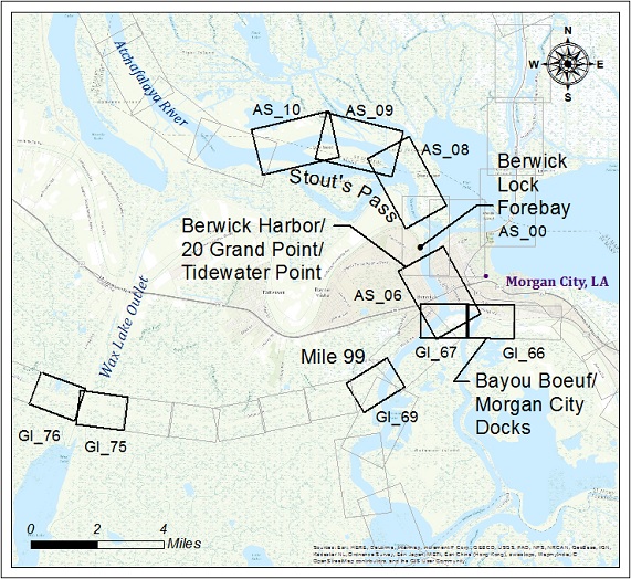
| Berwick Harbor | 07/07/2026 | ||
| AS_06_BER MM 120.0 to 122.0 | XYZ | Shape | |
| Berwick Lock Forebay | 07/07/2026 | ||
| AS_00_BLF | XYZ | Shape | |
| G.I.W.W. | |||
| Bayou Boeuf/Morgan City Docks | 06/17/2026 | ||
| GI_66_BBW MM 93.0 to 94.8 | XYZ | Shape | |
| 20 Grand Point/Tidewater Point | 06/17/2026 | ||
| GI_67_BBW MM 94.8 96.0 | XYZ | Shape | |
| Mile 99 | 06/03/2026 | ||
| GI_69_M99 MM 98.0 to 99.3 | XYZ | Shape | |
| Wax Lake Outlet - Sh. 75 | 06/03/2026 | ||
| GI_75_WLO MM 106.5.0 to 108.0 | XYZ | Shape | |
| Wax Lake Outlet - Sh. 76 | 06/03/2026 | ||
| GI_76_WLO MM 108.0 to 109.0 | XYZ | Shape | |